WATCH: Satellite Loop Shows Dramatic Ice Shift On Lake Superior That Led To Rescue Near Duluth
Late Tuesday morning, a shelf of ice that had formed at the head of Lake Superior broke away, pushed eastward by generally westerly winds that are leading to some of the frigid wind chills the Northland is experiencing lately.
When that ice broke away from shore, there was a group of ice anglers out fishing. While some of them were able to escape to shore before the ice floated away, 26 of then needed rescue by the Duluth Fire Department, St. Louis County Rescue Squad, and Coast Guard.
The rescue effort took about an hour. Thankfully rescue teams were able to execute the rescue in short order, because that sheet of ice that broke away was moving at a pretty good clip.
About an hour after the initial rescue call, the gap grew pretty drastically, and the sheet continued to cruise up past the Palmers area and beyond through the rest of the day.

The first satellite images are a comparison from the Lake Superior MODIS Imagery library. The first image is from 10:30 am on Monday, February 8. The second image is from 1 pm on Tuesday, February 9. Being there is only one image per day available from this source, it does a pretty good job of showing how the ice broke away and how far it had moved in the two hours or so it was free from shore. Note that there is additional ice (not where the fishermen were) to the east of the shoreline ice that basically disappears from Monday to Tuesday, getting blown eastward overnight, into the Bayfield Peninsula.
The second satellite loop shows shows a timespan from 1:50 pm to 5:00 pm on Tuesday, which is about 3 hours after the emergency call came in that the ice had broken away. It is a little hard to see in the full-size image, so you can scroll down to a zoomed-in version to see just how far the ice drifted over the 3 hours of the loop.
Here is a zoomed-in version of the satellite animation from above. You can see the fingernail-shaped ice chunk float away from the western shore, and work its way quite a distance from Duluth before the end of the loop at 5 pm.
You'll also notice what looks like clouds moving across most of Lake Superior. This is steam rolling off the open water, formed as the brutally cold air we are experiencing passes over the relatively warm water of the lake. This is the same type of thing that leads to the sea smoke we've recently been seeing.
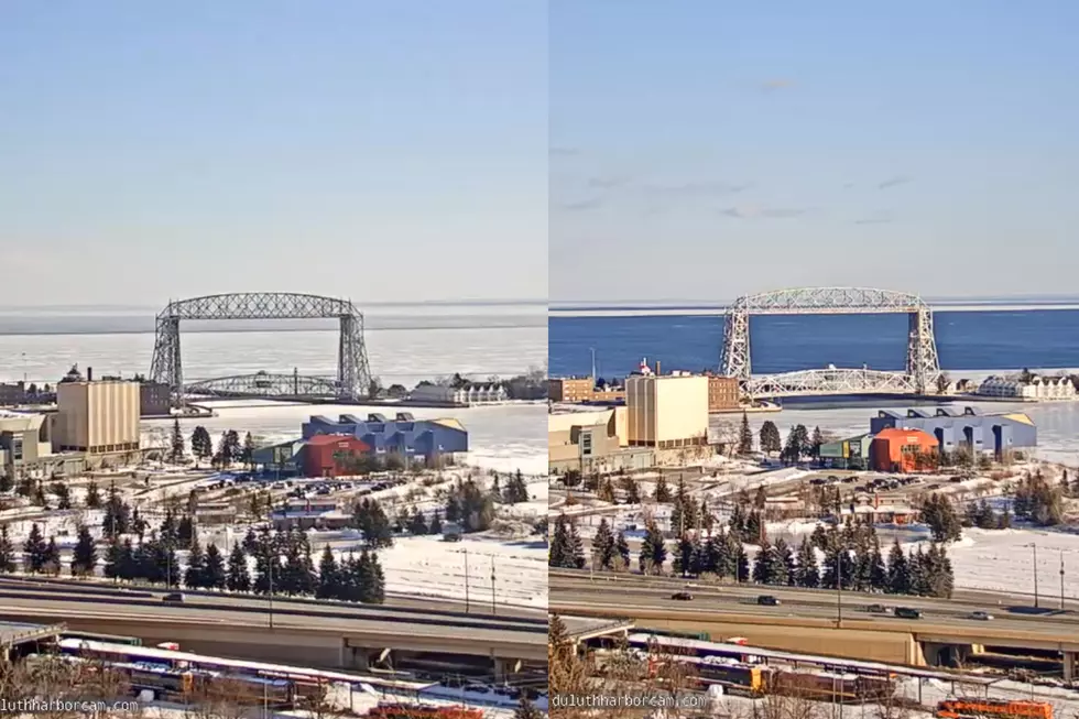
One other perspective on the moving ice are the Duluth Harbor Cams live feeds. You can see in the live video of both the Canal Park Cam and the Hillside Cam how much the ice moved through the day. Note that the live video only allows you to access the last 12 hours of video. After a certain period of time, you won't be able to scrub back to see this. If you want to time jump back in either of these videos, they are both below.
Just to offer some perspective, here is a 7-frame gif, starting at 11 am, with a new frame each hour to 5 pm. Images courtesy of DuluthHaborCam.com.
10 Major Winter Weather Events In Northland History
More From 106.5 The FAN