Thursday’s Severe Storms Also Bring Flooding Threat To Northern Minnesota
After what seemed like a winter that would never end, summerlike conditions have finally arrived in the Northland. Along with it, severe weather season has kicked into full force.
The National Weather Service is warning that Thursday's storms are bringing the potential of strong winds, large hail, and flooding across much of the region through Thursday night, and into the very early hours of Friday morning.
While storms on Monday and again Wednesday were strong, Thursday's storms reportedly have the potential to be generally stronger, with more widespread severe weather possible.
Areas to the west of the Twin Ports, including the Brainerd Lakes Area, are seeing the potential of tornadoes along with wind, hail, and flooding possibilities.
While not out of the question, tornadoes aren't the big concern for the Twin Ports area. Wind, hail, and heavy rain are the threats to be aware of for our region.

Heavy rain from Wednesday's storms, along with a line of storms that have moved through the state during the late morning and early afternoon hours of Thursday, have already led to some flooding across the region. Cook County, for example, is reporting some road washouts and standing water that have closed a few roads.
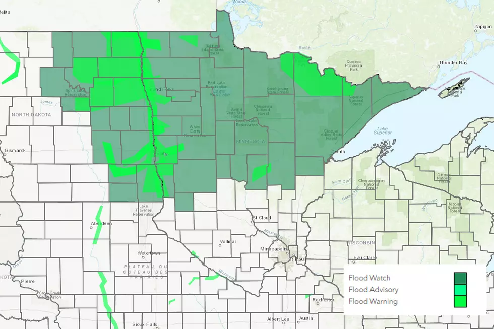
Many Northland waterways have already been seeing high water levels from spring snowmelt and rains. Add this week's rain events and the chance for more heavy rain with today's storms, and the National Weather Service was compelled to issue a flood watch for most of Northern Minnesota, including Carlton, St. Louis, and Lake Counties.
The watch is in effect from 10 am Thursday through Friday morning. The National Weather Service warns that excessive rain may result in flooding of rivers, creeks, streams, and other low-lying and flood-prone locations. Additionally, flooding may occur in areas with poor or blocked drainage in cities and towns.
An additional 1-1.5 inches of new rain could fall before rain concludes Friday morning, possibly falling in a short period of time. This means that if you live near flood-prone areas or travel roadways prone to flooding, you should monitor conditions and take appropriate action if flooding occurs.

Once storms move out Thursday night and into Friday morning, things look to calm down.
The forecast shows a pleasant day on Friday, with clearing through the day. As the Minnesota Fishing Opener kicks off on Saturday, there may be some passing clouds, but conditions should remain dry. Wrapping up the weekend, Sunday will see a slight chance of some afternoon showers, but otherwise another dry and pleasant day.
10 Major Summer Weather Events In Northland History
More From 106.5 The FAN